|
|
Post by kaima on Jan 8, 2020 13:01:20 GMT -7
|
|
|
|
Post by kaima on Jan 8, 2020 13:10:52 GMT -7
ALPEJSKIE AKWARELE - stycznia 04, 2020 Original source: www.refraktor.pl/2020/01/alpejskie-akwarele.htmlWszelkie pomiary od dawna wskazywały, że najwyższy szczyt Wielkiej Fatry - Ostredok jest wymarzonym punktem do obserwacji Alp. Wymarzonym w tym sensie, że realizacja tej obserwacji tkwiła długo w strefie marzeń. Coś jak sen o zostaniu pilotem z dzieciństwa... No i kiedyś trzeba te sny w końcu zrealizować. Z początkiem roku 2020 nastały odpowiednie ku temu warunki. Z analizy meteogramów wynikało, że nie warto gnać na sam wschód słońca, bo koło 10:00 - 11:00 powinno być najbardziej suche powietrze, a zimowe słońce i tak nie powinno zbyt namieszać w kwestii kontrastów. Więc budzik zerwał mnie z łóżka o 3:00 i po dwóch godzinach jazdy zaparkowałem w Vyšnej Revúcy u wylotu Zelenej Doliny, a następnie po prawie czterech godzinach dreptania przez zaśnieżone buczyny i kosówki docieram na Ostredok, gdzie jak najszybciej rozkładam statyw. 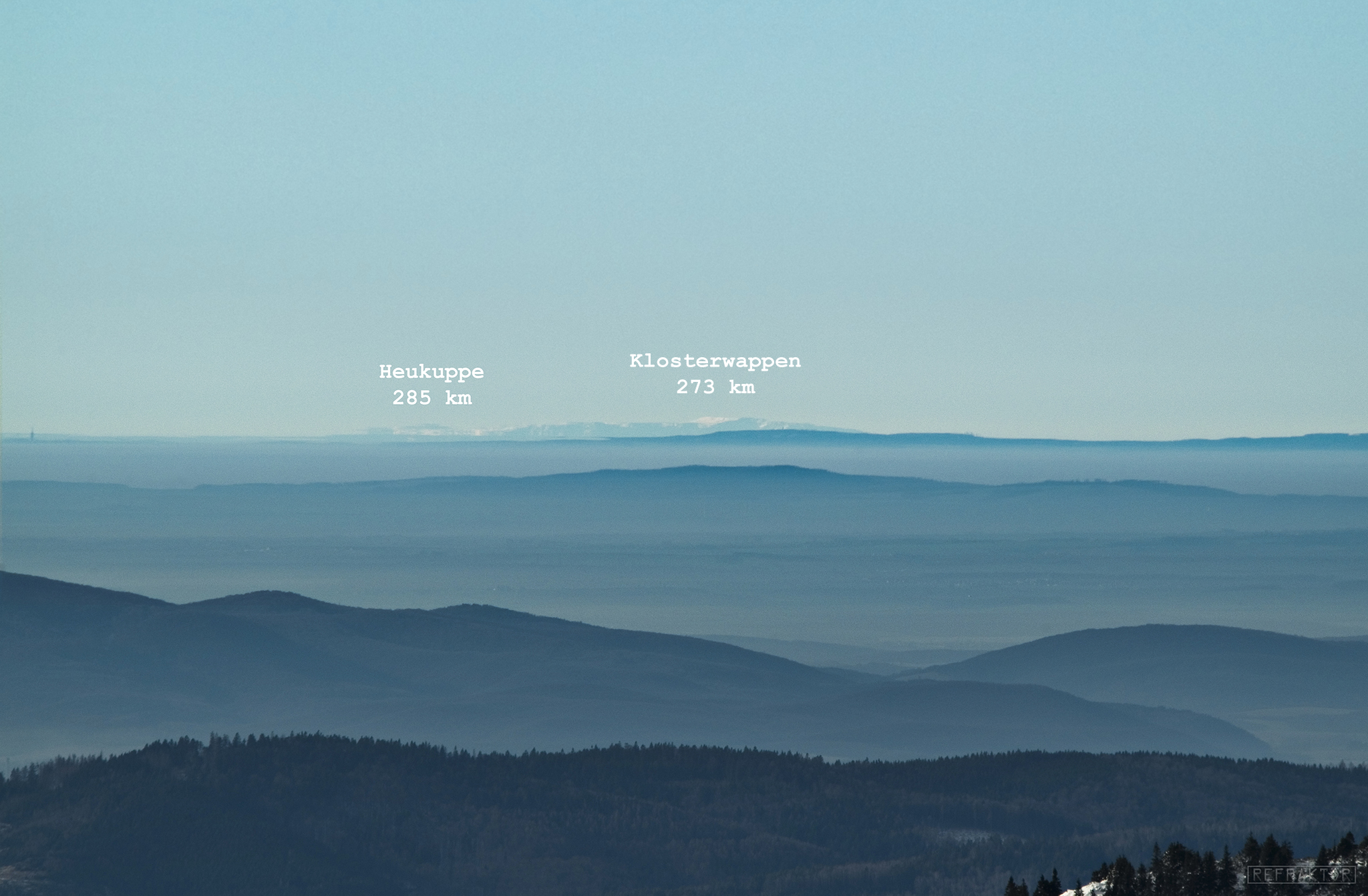 Jest przed południem, ale widać już wszystko co potrzeba. Dominuje mocno podniesiony masyw Schneebergu z najwyższym szczytem Klosterwappen (2076 m n.p.m.) i położony la lewo masyw Rax z najwyższym szczytem Heukuppe (2007 m n.p.m.). It is before noon, but you can see everything you need. The heavily raised Schneeberg massif with the highest Klosterwappen peak (2076 m a.s.l.) and the left Rax massif with the highest Heukuppe peak (2007 m a.s.l.) dominate. 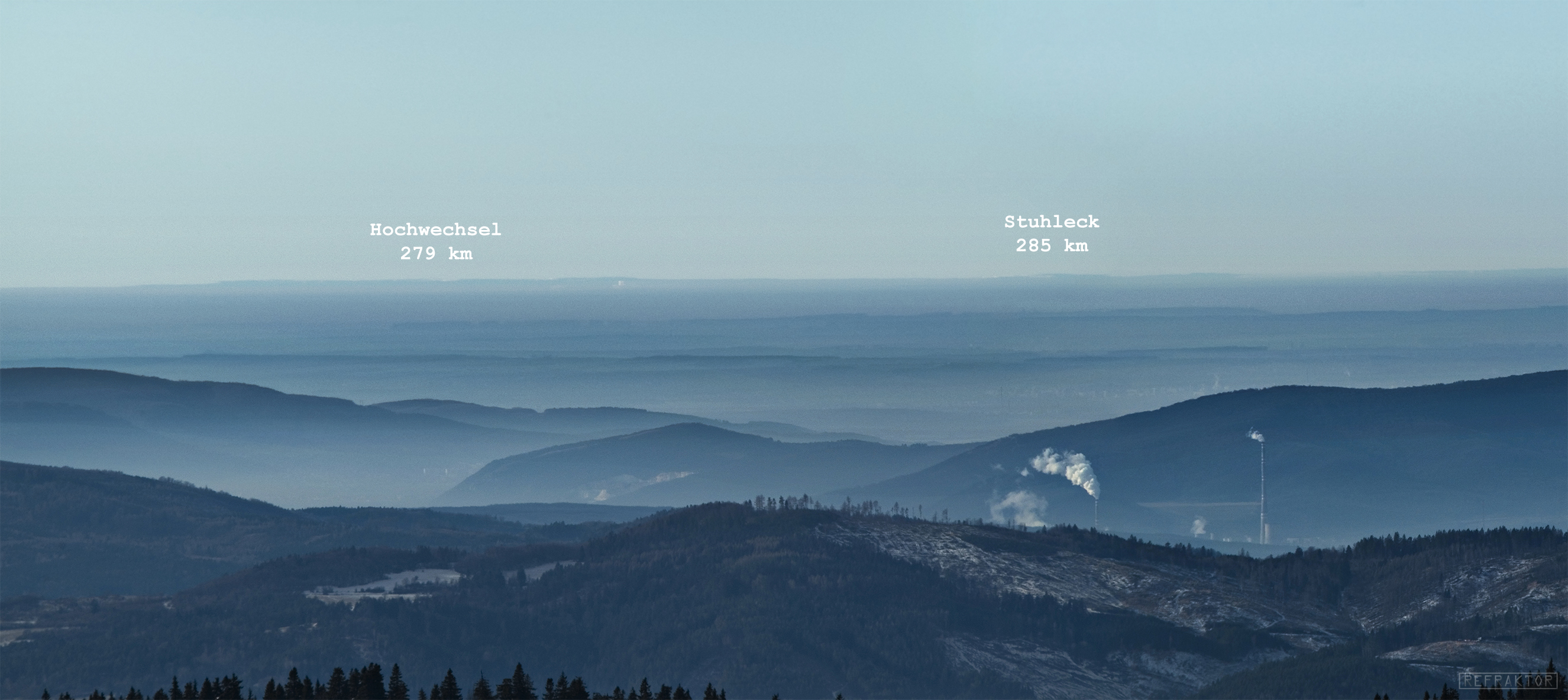 Panorama Randgebirge östlich der Mur. Mimo panującego wyżu, nie było bezwietrznie. Ów wyż nie stagnował, tylko gnał na wschód, a hulający wiatr oprócz rozmydlania kadrów, znacznie obniżał komfort termiczny. Więc trzeba było ruszyć rzyć w kierunku Krížnej, by nie zmarznąć. Warunki i tak nie powinny ulec zmianie, dopóki słońce nie zejdzie bliżej horyzontu. W zasadzie przez cały dzień występowała zwiększona refrakcja atmosferyczna, ale wieczorem zjawisko się spotęgowało i rozmyło Alpy w fantastyczne akwarelowe miraże. Panorama of Randgebirge östlich der Mur. Despite the high boom, it was not windless. This high did not stagnate, only ran east, and the booming wind, apart from blurring the frames, significantly reduced thermal comfort. So you had to move towards Krížna not to freeze. The conditions should not change anyway until the sun goes down closer to the horizon. In fact, there was increased atmospheric refraction throughout the day, but in the evening the phenomenon intensified and blurred the Alps into fantastic watercolor mirages 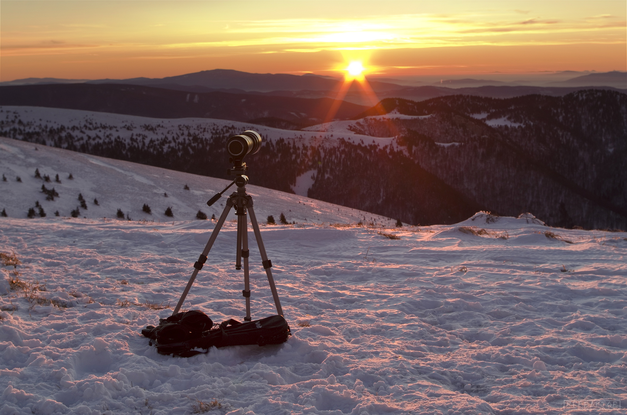 Po powrocie z Krížnej rozstawiam statyw w tym samym miejscu. Wiatr co prawda słabnie, ale czasy naświetlania też się wydłużają. Nie ma też co szukać innego miejsca, bo obszedłem całą kopułę szczytową w te i na zad i wszędzie duje. After returning from Krížna, I set up the tripod in the same place. The wind is weakening, but the exposure times are also getting longer. There is also no need to look for another place, because I have rounded the entire top dome in these and on the croup, and it roars everywhere. 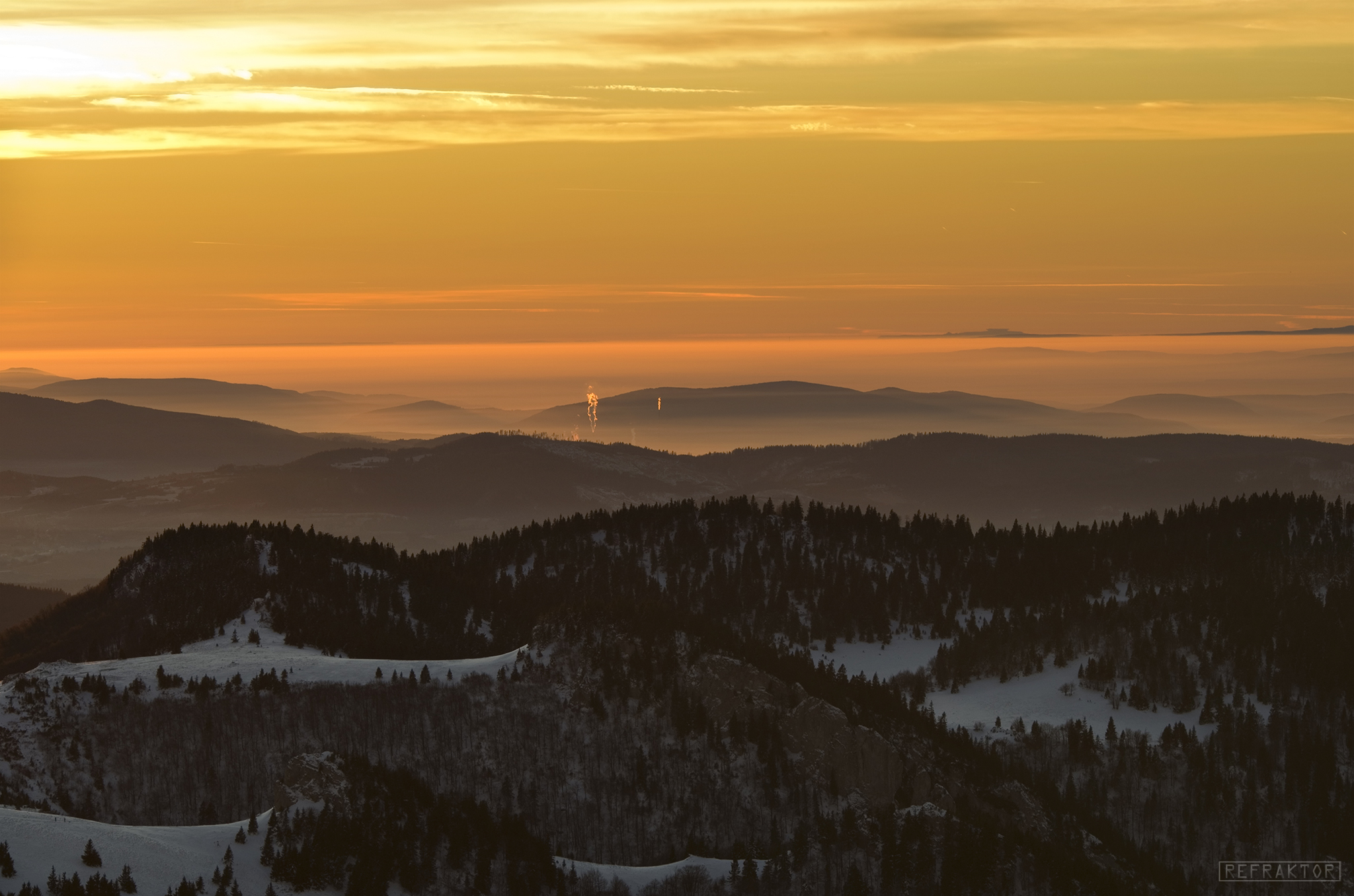 Ogólna sytuacja w kierunku na Alpy. Schneeberg był wyraźnie widoczny gołym okiem, ale niewielkie kreski Hohwechsel i Stuhlecka można było dostrzec tylko na większej ogniskowej. General situation towards the Alps. Schneeberg was clearly visible to the naked eye, but the small lines of Hohwechsel and Stuhleck could only be seen at a larger focal length. Original source: www.refraktor.pl/2020/01/alpejskie-akwarele.html |
|
|
|
Post by pieter on Jan 8, 2020 16:42:03 GMT -7
Kai,
I remember the view from our Belgian Walloon Ardennes mountains holiday house in the Ferrières muncipality in the Province of Liège in the Wallonia primarily French-speaking part of Belgium. With a clear sky we could watch about 50 to 70 kilometers over the mountains in that mountain scape view over there. But we never had views of 285 km (177.091 miles), 273 km (169.634 miles), and 279 km (173.363 miles), like the views from the Great Fatra mountain range in the Western Carpathians in Slovakia to Heukuppe, Klosterwappen, Hochwechsel and Stuhleck in the Rax mountain range in the Northern Limestone Alps on the border of the Austrian federal provinces of Lower Austria and Styria. Stuhleck Stuhleck (1,782 m) is a mountain in Steiermark, Austria. It is the highest mountain of the Fischbach Alps and of the Prealps east of the Mur. Stuhleck (1,782 m) is a mountain in Steiermark, Austria. It is the highest mountain of the Fischbach Alps and of the Prealps east of the Mur.
Lying in the sparsely populated commune of Spital am Semmering, Stuhleck is a grassy mountain with gentle slopes, although its lower slopes are heavily wooded. With the summit being above the treeline, it offers fine views of some of the higher alpine ranges to the west, and it is a fairly easy hike to the top.The Rax The Rax is a mountain range in the Northern Limestone Alps on the border of the Austrian federal provinces of Lower Austria and Styria. Its highest peak is the Heukuppe (2,007 m). The Rax, together with the nearby Schneeberg, are a traditional mountaineering and mountain walking area, and are called the Wiener Hausberge (Vienna's local mountains). They are separated by the deep Höllental ("Hell Valley"). The Rax is a mountain range in the Northern Limestone Alps on the border of the Austrian federal provinces of Lower Austria and Styria. Its highest peak is the Heukuppe (2,007 m). The Rax, together with the nearby Schneeberg, are a traditional mountaineering and mountain walking area, and are called the Wiener Hausberge (Vienna's local mountains). They are separated by the deep Höllental ("Hell Valley"). Cable car „Rax-Seilbahn“A cable car, the Raxseilbahn, starting at Hirschwang at the north-eastern foot of the mountains and the first in Austria (construction began in 1925), takes visitors to the extensive, high plateau of the Rax at a height of about 1,500 m. This area is a particular favourite with hikers from Lower Austria and Vienna. The steep sides of the plateau offer climbing tours of various difficulty. These steige (mountain trails) and the hütten, alpine huts offering basic accommodation, were built and are maintained kept by various Austrian Alpine Clubs. They were erected in the late 19th and early 20th century. Cable car „Rax-Seilbahn“A cable car, the Raxseilbahn, starting at Hirschwang at the north-eastern foot of the mountains and the first in Austria (construction began in 1925), takes visitors to the extensive, high plateau of the Rax at a height of about 1,500 m. This area is a particular favourite with hikers from Lower Austria and Vienna. The steep sides of the plateau offer climbing tours of various difficulty. These steige (mountain trails) and the hütten, alpine huts offering basic accommodation, were built and are maintained kept by various Austrian Alpine Clubs. They were erected in the late 19th and early 20th century. The Heukuppe in the Rax mountain range The Heukuppe in the Rax mountain range The Schneeberg, with its 2,076-metre (6,811 ft) high summit Klosterwappen, is the highest mountain of Lower Austria, and the easternmost mountain in the Alps to exceed 2000 m. It is a distinctive limestone massif with steep slopes on three sides.The Schneeberg is one of the Northern Calcareous Alps in the borderland between Lower Austria and Styria, in the eastern part of Austria. It and the Rax (2,007 m or 6,585 ft), some 13 km (8.1 mi) to the south-west, are collectively considered the Viennese Hausberge (Vienna's "local mountains"). The rich Karst plateaux have provided drinking water for Vienna, via a 120 km (75 mi) long pipeline, since 1873, and is claimed to be the best drinking water in the world. The Schneeberg, with its 2,076-metre (6,811 ft) high summit Klosterwappen, is the highest mountain of Lower Austria, and the easternmost mountain in the Alps to exceed 2000 m. It is a distinctive limestone massif with steep slopes on three sides.The Schneeberg is one of the Northern Calcareous Alps in the borderland between Lower Austria and Styria, in the eastern part of Austria. It and the Rax (2,007 m or 6,585 ft), some 13 km (8.1 mi) to the south-west, are collectively considered the Viennese Hausberge (Vienna's "local mountains"). The rich Karst plateaux have provided drinking water for Vienna, via a 120 km (75 mi) long pipeline, since 1873, and is claimed to be the best drinking water in the world.
On clear days, Schneeberg can be readily seen from parts of Vienna, some 65 km (40 mi) away (as the crow flies), from Bratislava in Slovakia and even from Babí Lom above Brno 180 km away.
A rack-and-pinion railway, the Schneeberg Railway, now over 100 years old, climbs to a height of 1,800 m (5,900 ft), reducing the walk to the summit to an hour or two. There are also a number of other routes for walkers, including from the spa resort of Puchberg am Schneeberg to the east, or from the south, in Höllental.
The summit plateau has a number of mountain huts which are visited by thousands of walkers, climbers and even mountain-bikers each year.The Wechsel The Wechsel is a low mountain range in eastern Austria whose highest summit is the Hochwechsel (1,743 m above sea level (AA)). It also has two other summits over 1700 m. The massif forms the border between the states of Lower Austria and Styria for about 15 km, southeast of the Semmering and northeast of the Graz Basin, between the Feistritz Saddle and the eponymous pass of Wechsel. The Wechsel is a low mountain range in eastern Austria whose highest summit is the Hochwechsel (1,743 m above sea level (AA)). It also has two other summits over 1700 m. The massif forms the border between the states of Lower Austria and Styria for about 15 km, southeast of the Semmering and northeast of the Graz Basin, between the Feistritz Saddle and the eponymous pass of Wechsel. The Hochwechsel The Hochwechsel
|
|
|
|
Post by Jaga on Jan 10, 2020 5:20:31 GMT -7
Beautiful pictures. It reminds me my trips to the mountains in the past. One Spring we walked at Slovakia mountains, one winter I was even skiing a bit, buT I was never a good skier.
I remember Velka Fatra and Mala Fatra since they are relatively easy to reach.
Thanks for bringing my old memories
|
|