|
|
Post by pieter on Jul 16, 2021 7:01:37 GMT -7
|
|
|
|
Post by pieter on Jul 16, 2021 7:36:04 GMT -7
|
|
|
|
Post by pieter on Jul 16, 2021 7:36:46 GMT -7
|
|
|
|
Post by pieter on Jul 16, 2021 7:37:30 GMT -7
Watch this video on YouTube
|
|
|
|
Post by pieter on Jul 16, 2021 7:38:59 GMT -7
|
|
|
|
Post by pieter on Jul 16, 2021 7:40:03 GMT -7
Disastrous floods in Belgium. Here you see the destructive power of water masses
|
|
|
|
Post by pieter on Jul 16, 2021 7:42:30 GMT -7
Liège in the French speaking part of Belgium
Liège (/liˈɛʒ, liˈeɪʒ/ lee-EZH, lee-AYZH, French: [ljɛʒ] (About this soundlisten), locally [li.eːʃ]; Walloon: Lidje [liːtʃ]; Dutch: Luik [lœyk] (About this soundlisten); German: Lüttich German: [ˈlʏtɪç] (About this soundlisten); Latin: Leodium) is a major Walloon city and municipality and the capital of the Belgian province of Liège.
The city is situated in the valley of the Meuse, in the east of Belgium, not far from borders with the Netherlands (Maastricht is about 33 km (20.5 mi) to the north) and with Germany (Aachen is about 53 km (32.9 mi) north-east). At Liège, the Meuse meets the River Ourthe. The city is part of the sillon industriel, the former industrial backbone of Wallonia. It still is the principal economic and cultural centre of the region.
|
|
|
|
Post by pieter on Jul 16, 2021 7:45:45 GMT -7
Belgium - French speaking part - the Walloon city Verviers
Verviers (French pronunciation: [vɛʁvje]; Walloon: Vervî) is a Walloon city and municipality located in the Belgian province of Liège.
The municipality of Verviers includes the old communes of Ensival, Lambermont, Petit-Rechain, Stembert, and Heusy. It is also the center of an agglomeration that includes Dison and Pepinster, making it the second biggest in the province and an important regional center, located roughly halfway between Liège and the German border.
Water has played an important role in the town's economy, notably in the development first of its textile and later its tourist industries. As a result, many fountains have been built in Verviers, leading it to be named Wallonia's "Water Capital". The seats of the two Walloon public institutions for water distribution and water treatment are located in the town.
|
|
|
|
Post by pieter on Jul 16, 2021 7:47:11 GMT -7
Belgium - Wallonia - French speaking part
|
|
|
|
Post by pieter on Jul 16, 2021 7:51:10 GMT -7
|
|
|
|
Post by pieter on Jul 16, 2021 7:55:27 GMT -7
These floods take place in the Rhine–Meuse–Scheldt delta Jaga. A river delta in the Netherlands formed by the confluence of the Rhine, the Meuse (Dutch: Maas) and the Scheldt rivers. In some cases, the Scheldt delta is considered a separate delta to the Rhine-Meuse delta. The result is a multitude of islands, branches and branch names that may at first sight look bewildering, especially as a waterway that appears to be one continuous stream may change names as many as seven times, e.g. Rhine → Bijlands Kanaal → Pannerdens Kanaal → Nederrijn → Lek → Nieuwe Maas → Het Scheur → Nieuwe Waterweg (→ North Sea). Since the Rhine contributes most of the water, the shorter term Rhine Delta is commonly used. However, this name is also used for the delta where the Alpine Rhine flows into Lake Constance, so it is clearer to call the larger one Rhine–Meuse delta, or even Rhine–Meuse–Scheldt delta, as the Scheldt ends in the same delta. By some calculations, the delta covers 25,347 km2 (9,787 sq mi), making it the largest in Europe. In some cases, the Scheldt delta is considered a separate delta to the Rhine-Meuse delta. The result is a multitude of islands, branches and branch names that may at first sight look bewildering, especially as a waterway that appears to be one continuous stream may change names as many as seven times, e.g. Rhine → Bijlands Kanaal → Pannerdens Kanaal → Nederrijn → Lek → Nieuwe Maas → Het Scheur → Nieuwe Waterweg (→ North Sea). Since the Rhine contributes most of the water, the shorter term Rhine Delta is commonly used. However, this name is also used for the delta where the Alpine Rhine flows into Lake Constance, so it is clearer to call the larger one Rhine–Meuse delta, or even Rhine–Meuse–Scheldt delta, as the Scheldt ends in the same delta. By some calculations, the delta covers 25,347 km2 (9,787 sq mi), making it the largest in Europe.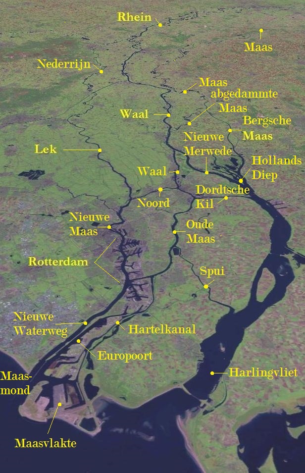 The economic importance of the Rhine–Meuse–Scheldt delta is enormous, since the three rivers are important navigable waterways. The delta is the entrance from the North Sea to the vast German and Central European hinterland (and to a lesser extent France). Major ports in the delta are Rotterdam, Antwerp (Belgium), Vlissingen, Amsterdam (through the Amsterdam–Rhine Canal), and Ghent (through the Ghent–Terneuzen Canal). The land areas in the delta are protected from flooding by the Dutch Delta Works.GeographyThe shape of the Rhine delta is determined by two bifurcations: firstly, at Millingen aan de Rijn, the Rhine splits into the Waal and the Nederrijn, and secondly near Arnhem, the IJssel branches off from the Nederrijn. This creates three main flows, two of which change names rather often. The largest and southern main branch begins as the Waal and continues as the Boven Merwede ("Upper Merwede"), the Beneden Merwede ("Lower Merwede"), the Noord River ("North River"), the Nieuwe Maas ("New Meuse"), Het Scheur ("the Rip") and the Nieuwe Waterweg ("New Waterway"). The middle flow begins as the Nederrijn, then changes into the Lek, then joins the Noord, thereby forming the Nieuwe Maas. The northern flow keeps the name IJssel until it flows into Lake IJsselmeer. Three more flows carry significant amounts of water: the Nieuwe Merwede ("New Merwede"), which branches off from the southern branch where it changes from the Boven to the Beneden Merwede; the Oude Maas ("Old Meuse"), which branches off from the southern branch where it changes from the Benede Merwede into the Noord, and the Dordtsche Kil, which branches off from the Oude Maas. The economic importance of the Rhine–Meuse–Scheldt delta is enormous, since the three rivers are important navigable waterways. The delta is the entrance from the North Sea to the vast German and Central European hinterland (and to a lesser extent France). Major ports in the delta are Rotterdam, Antwerp (Belgium), Vlissingen, Amsterdam (through the Amsterdam–Rhine Canal), and Ghent (through the Ghent–Terneuzen Canal). The land areas in the delta are protected from flooding by the Dutch Delta Works.GeographyThe shape of the Rhine delta is determined by two bifurcations: firstly, at Millingen aan de Rijn, the Rhine splits into the Waal and the Nederrijn, and secondly near Arnhem, the IJssel branches off from the Nederrijn. This creates three main flows, two of which change names rather often. The largest and southern main branch begins as the Waal and continues as the Boven Merwede ("Upper Merwede"), the Beneden Merwede ("Lower Merwede"), the Noord River ("North River"), the Nieuwe Maas ("New Meuse"), Het Scheur ("the Rip") and the Nieuwe Waterweg ("New Waterway"). The middle flow begins as the Nederrijn, then changes into the Lek, then joins the Noord, thereby forming the Nieuwe Maas. The northern flow keeps the name IJssel until it flows into Lake IJsselmeer. Three more flows carry significant amounts of water: the Nieuwe Merwede ("New Merwede"), which branches off from the southern branch where it changes from the Boven to the Beneden Merwede; the Oude Maas ("Old Meuse"), which branches off from the southern branch where it changes from the Benede Merwede into the Noord, and the Dordtsche Kil, which branches off from the Oude Maas. Before the St. Elizabeth's flood (1421) the Meuse flowed just south of today's line Merwede–Oude Maas to the North Sea and formed an archipelago-like estuary with the Waal and the Lek. This system of numerous bays, estuary-like extended rivers, many islands and constant changes of the coastline, is hard to imagine today. From 1421 to 1904, the Meuse and the Waal merged further upstream at Gorinchem to form the Merwede. For flood protection reasons, the Meuse was separated from the Waal through a lock and diverted into a new outlet called the "Bergse Maas", then the Amer flowing into the former bay known as the Hollands Diep. Before the St. Elizabeth's flood (1421) the Meuse flowed just south of today's line Merwede–Oude Maas to the North Sea and formed an archipelago-like estuary with the Waal and the Lek. This system of numerous bays, estuary-like extended rivers, many islands and constant changes of the coastline, is hard to imagine today. From 1421 to 1904, the Meuse and the Waal merged further upstream at Gorinchem to form the Merwede. For flood protection reasons, the Meuse was separated from the Waal through a lock and diverted into a new outlet called the "Bergse Maas", then the Amer flowing into the former bay known as the Hollands Diep.
The northwestern part of the estuary (around Hook of Holland), is still called Maasmond ("Meuse Mouth"), ignoring the fact that it now carries only water from the Rhine. This might explain the confusing naming of the various branches.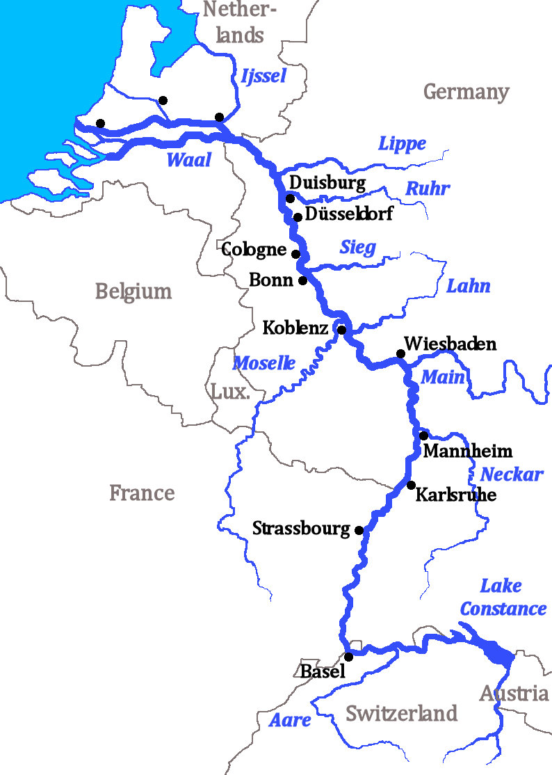 The hydrography of the current delta is characterized by the delta's main arms, disconnected arms (Hollandse IJssel, Linge, Vecht, etc.) and smaller rivers and streams. Many rivers have been closed ("dammed") and now serve as drainage channels for the numerous polders. The construction of Delta Works changed the delta in the second half of the 20th century fundamentally. Currently Rhine water runs into the sea, or into former marine bays now separated from the sea, in five places, namely at the mouths of the Nieuwe Merwede, Nieuwe Waterway (Nieuwe Maas), Dordtse Kil, Spui and IJssel. The hydrography of the current delta is characterized by the delta's main arms, disconnected arms (Hollandse IJssel, Linge, Vecht, etc.) and smaller rivers and streams. Many rivers have been closed ("dammed") and now serve as drainage channels for the numerous polders. The construction of Delta Works changed the delta in the second half of the 20th century fundamentally. Currently Rhine water runs into the sea, or into former marine bays now separated from the sea, in five places, namely at the mouths of the Nieuwe Merwede, Nieuwe Waterway (Nieuwe Maas), Dordtse Kil, Spui and IJssel.
The Rhine–Meuse Delta is a tidal delta, shaped not only by the sedimentation of the rivers, but also by tidal currents. This meant that high tide formed a serious risk because strong tidal currents could tear huge areas of land into the sea. Before the construction of the Delta Works, tidal influence was palpable up to Nijmegen, and even today, after the regulatory action of the Delta Works, the tide acts far inland. At the Waal, for example, the most landward tidal influence can be detected between Brakel and Zaltbommel.History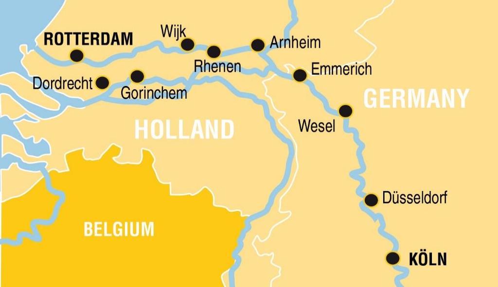 Already in the time of Julius Caesar, the "Island of the Batavi" was known to the Romans. Its eastern point was the split of the Rhine into the Oude Rijn and the Waal, which at this time were the two main branches of the Rhine. The Waal flowed into the Meuse in the Roman period. Already in the time of Julius Caesar, the "Island of the Batavi" was known to the Romans. Its eastern point was the split of the Rhine into the Oude Rijn and the Waal, which at this time were the two main branches of the Rhine. The Waal flowed into the Meuse in the Roman period.
Pliny the Elder's Natural History gives a list of tribes living in the "Gaulish islands" within the delta region between different mouths of the Rhine. First he mentions the large island of the Batavians and the Cananefates. Then he gives the list of other peoples who he says are stretched out along 100 Roman miles, between the mouth of the Helinius (understood to be the main mouth of the Meuse, where the Waal (Latin: Vacalis) also discharged) and the Roman fortification at Flevum (a port north of the Old Rhine). The Roman castrum at Flevumwas mentioned by Tacitus, and is equated today with Velsen. Although the details are no longer clear, there was apparently sometimes an extension of the Old IJ that came close to the north sea here. But the term Flevo was also have used by Pomponius Mela to refer to the fresh water lakes which were in the area of the modern Zuiderzee, which Mela specifically says that the Rhine fed into. So the Rhine mouth mentioned by Pliny might have been a discharge into a lake, or perhaps water running to Flevum on the coast may have run via the lakes to the coast, perhaps first through an ancient version of the Vecht, or the IJssel. The IJssel however was joined to the Rhine artificially, by Drusus, and is quite far from any of the places known to be called Flevus. Suetonius says that this channel was still referred to as Drusus' fossa in his time. Some authors have argued that the mouth Pliny mentions is the Vlie, much further to the north than Velsen where the main waters of the lake entered the North Sea. A maps of the many rivers in the River delta area in the Netherlands, Germany and Belgium A maps of the many rivers in the River delta area in the Netherlands, Germany and Belgium
|
|
|
|
Post by pieter on Jul 16, 2021 8:09:27 GMT -7
German and Belgian towns, wilde, aggressive and destructive floods
Watch that huge orange container dragged through a German street by the water
|
|
|
|
Post by pieter on Jul 16, 2021 9:23:00 GMT -7
 Scores dead, hundreds missing after massive floods in Germany, Belgium Scores dead, hundreds missing after massive floods in Germany, Belgium German emergency responders were on Friday still searching for hundreds of missing people after the worst floods in living memory killed 103 people in the country's west.German emergency responders were on Friday still searching for hundreds of missing people after the worst floods in living memory killed 103 people in the country's west. German emergency responders were on Friday still searching for hundreds of missing people after the worst floods in living memory killed 103 people in the country's west.German emergency responders were on Friday still searching for hundreds of missing people after the worst floods in living memory killed 103 people in the country's west.
"I fear that we will only see the full extent of the disaster in the coming days," Chancellor Angela Merkel said from Washington, where she met with President Joe Biden.
/cloudfront-us-east-2.images.arcpublishing.com/reuters/NKHF6HY3BJIKLJEGFMCG3QZEEA.jpg)
"I fear that we will only see the full extent of the disaster in the coming days," Chancellor Angela Merkel said from Washington, where she met with President Joe Biden.
Catching residents of several regions unaware and leaving destruction and despair in their wake, the masses of water were dubbed the "flood of death" by top-selling daily Bild.
Neighbouring Belgium counted at least 18 dead, while Luxembourg and the Netherlands were also severely affected by the torrents of water, with thousands evacuated in the city of Maastricht.
But Germany's toll was by far the highest at 103, and likely to rise with large numbers of people still missing in North Rhine-Westphalia and Rhineland-Palatinate, the hardest-hit states.
In the devastated Ahrweiler district of Rhineland-Palatinate around 1,300 people were unaccounted for, although local authorities told Bild the high number was likely down to damaged phone networks.
Regional interior minister Roger Lewentz told broadcaster SWR that "we believe there are still 40, 50 or 60 people missing, and when you haven't heard for people for such a long time ... you have to fear the worst."
"The number of victims will likely keep rising in the coming days," he added.'Disaster' What's more, continuing rain is forecast for parts of the west, where water levels in the Rhine river and its tributaries are rising dangerously. What's more, continuing rain is forecast for parts of the west, where water levels in the Rhine river and its tributaries are rising dangerously.
Around 1,000 soldiers have been deployed to help with rescue operations and rubble-clearing in affected towns and villages.
Streets and houses under water, overturned cars and uprooted trees could be seen everywhere the floodwaters had passed, while some districts were cut off from the outside world.
In Ahrweiler several houses collapsed completely, leaving the impression the town had been struck by a tsunami.
At least 20 people had been confirmed dead in Euskirchen, one of the worst-hit towns just to the north.
Its normally spick and span centre had been turned into a heap of rubble, with house facades torn off by the rushing floods.
Adding to the town's woes, a nearby dam remains at risk of giving way.
"My empathy and my heart go out to all of those who in this catastrophe lost their loved ones, or who are still worrying about the fate of people still missing," Merkel told reporters in Washington.
She said her government would not leave those affected "alone with their suffering", adding that it was doing its "utmost to help them in their distress".
Pensioner Annemarie Mueller, 65, looking out at her flooded garden and garage from her balcony, said her town of Mayen had been completely unprepared for the destruction.
"Where did all this rain come from? It's crazy," she told AFP, recalling the floodwater crashing through her street during the night.
"It made such a loud noise and given how fast it came down, we thought it would break the door down."
Four people are still missing in Belgium and the army has been sent to four of the country's 10 provinces to help with rescue and evacuations.
With homes under water since Wednesday, people from resort town Spa were being put up in tents.
The swollen Meuse river "is going to look very dangerous for Liege", a nearby city of 200,000 people, said Wallonia regional president Elio Di Rupo.Climate change? The storms have put climate change back at the centre of Germany's election campaign ahead of a September 26 parliamentary poll marking the end of Merkel's 16 years in power. The storms have put climate change back at the centre of Germany's election campaign ahead of a September 26 parliamentary poll marking the end of Merkel's 16 years in power.
Germany "must prepare much better" in future, Interior Minister Horst Seehofer said, adding that "this extreme weather is a consequence of climate change".
Because a warmer atmosphere holds more water, climate change increases the risk and intensity of flooding from extreme rainfall.
In urban areas with poor drainage and buildings located in flood zones, the damage can be severe.
Political candidates were quick to open a bidding war on climate following the floods.
North Rhine-Westphalia premier Armin Laschet, the conservative running to succeed Merkel, called for "speeding up" global efforts to fight climate change, underlining the link between global warming and extreme weather.(FRANCE 24 with AFP) |
|
|
|
Post by pieter on Jul 16, 2021 9:32:53 GMT -7
|
|
|
|
Post by pieter on Jul 16, 2021 9:49:11 GMT -7
Scary and sad images of burning houses in the flood waves. Probably gas pipeline were hit by the water floods and probably electricty lines which were hit also fueled the gas.
This is the French speaking Walloon party of Belgium near the German border.
|
|