|
|
Post by pieter on Oct 27, 2021 14:03:58 GMT -7
The place where I grew up was a battle ground during the final stages of the Second World War. Thousands of British, Canadian, Polish, Belgian, Dutch, Norwegian, German and Austrian soldiers died during that tough battle in Zeeland. Many civilians in the cities, towns, villages and hamlets died as well due to shrapnel, bombs, artillery fire, fire from allied Navy ships from the North sea and etc.
November 1944. On the flooded isle of Walcheren, Zeeland, thousands of Allied soldiers are battling the German army. Three young lives become inextricably connected. A Dutch boy trained by the German SS in Bavaria (Germany) fighting for the Germans on the Eastern Front for the Waffen SS whom is transfered to Zeeland, an English glider pilot and a girl from Zeeland connected to the resistance against her will, are forced to make crucial choices that impact both their own freedom and the freedom of others.
The language spoken is Dutch. You see images of German Wehrmacht soldiers, a Wehrmacht general, a few Waffen SS men, a British crew of a shot down plane which was heading for Market Garden in the Mid East of the Netherlands (which they would never reach from these South-Western Zeeland Islands through occupied German/Austrian Nazi territory), a Dutch Waffen SS young man who first fought on the Eastern Front and then was transfered to the West, and inbetween images of the Dutch resistance members in Zeeland who stole maps from a library and archive, and took clandestine images of German artillery, Atlantic Wall and Machine gun positions, which were transfered over the Westerscheldt to the Other part of Zeeland where the Canadians were. Many of these resistance fighters were caught, tortured by the SS police, SD or Gestapo, and many of them were executed. But their heroic work saved many Canadian, British, Polish, Belgian (Commando's), Norwegian (Commando's) en Dutch army soldiers lives. Their sacrifice was not in vain.
|
|
|
|
Post by pieter on Oct 27, 2021 14:06:49 GMT -7
Battle of the Scheldt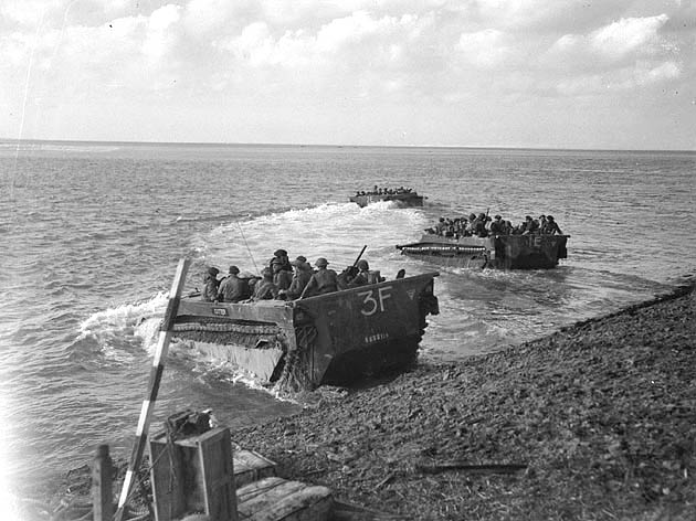 The Battle of the Scheldt in World War II was a series of military operations led by the First Canadian Army, with Canadian, Polish and British units attached, to open up the shipping route to Antwerp so that its port could be used to supply the Allies in north-west Europe. Under acting command of the First Canadian's Lieutenant-General Guy Simonds, the battle took place in northern Belgium and southwestern Netherlands from 2 October to 8 November, 1944. The Battle of the Scheldt in World War II was a series of military operations led by the First Canadian Army, with Canadian, Polish and British units attached, to open up the shipping route to Antwerp so that its port could be used to supply the Allies in north-west Europe. Under acting command of the First Canadian's Lieutenant-General Guy Simonds, the battle took place in northern Belgium and southwestern Netherlands from 2 October to 8 November, 1944.

Lieutenant-General Guy Granville Simonds, CC, CB, CBE, DSO, CD (April 23, 1903 – May 15, 1974) was a senior Canadian Army officer who served with distinction during World War II, where he commanded the 1st Canadian Infantry Division and II Canadian Corps. In 1951, at the age of just 48, he was appointed Chief of the General Staff, the most senior member of the Canadian Army, a post he held for four years.
The well-established Wehrmacht defenders staged an effective delaying action, during which the Germans flooded land areas in the Scheldt estuary, slowing the Allied advance. After five weeks of difficult fighting, the Canadian First Army, at a cost of 12,873 Allied casualties (half of them Canadian), was successful in clearing the Scheldt after numerous amphibious assaults, obstacle crossings, and costly assaults over open ground.
Once the German defenders were no longer a threat, it took another three weeks to de-mine the harbours; the first convoy carrying Allied supplies was not able to unload in Antwerp until 29 November, 1944.
|
|
|
|
Post by pieter on Oct 27, 2021 14:31:35 GMT -7
Old newsreel of the Battle of the Scheldt. The Battle of the Scheldt was a series of military operations by the Canadian First Army - consisting of Canadian, British and Polish formations - to open up the port of Antwerp so that it could be used to supply the Allies in north-west Europe. Led by Guy Simonds, the battle took place in northern Belgium and southwestern Netherlands during World War II from October 2 to November 8, 1944.
Source: Canadian Archives
|
|
|
|
Post by pieter on Oct 27, 2021 14:33:56 GMT -7
Good documentary of the Zeeland Broadcast Corporation with real live witnesses of Zeeland people from the Walcheren Peninsula in real Zeelandic dialect. Farm people and small town and village people. Very well done by my Zeeland colleagues. As a child and teenager I played with other boys in, on and around these Bunkers on Walcheren. That was very adventurous and sometimes not without danger. You could fell off these concrete constuctions and harm yourself with the rusty metal parts or concrete of the bunkers, also the lower platforms of them.
|
|
|
|
Post by pieter on Oct 27, 2021 14:43:07 GMT -7
Imagine a formation of 30 Lancaster bombers, what a sound that must have been.WestkapelleWestkapelle is a small city in the municipality of Veere on the island Walcheren, in the province Zeeland of the Netherlands. On 1 January 2021, it had a population of 2,632. Westkapelle is on the westernmost tip of Walcheren and is surrounded by the sea on three sides.
Westkapelle was a separate municipality from 1816 until 1997, when it was merged with Veere.

A visible reminder of the Second World War is the brackish lake formed by the inrushing flood when the dike was bombed
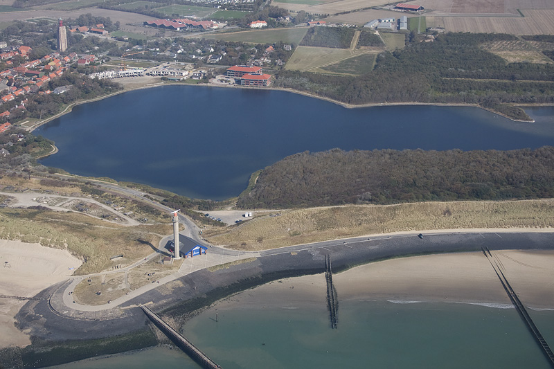
The brackish lake in Westkapelle on the Walcheren Peninsula in Zeeland
On 3 October 1944, the dyke to the south of Westkapelle was destroyed by British Lancaster bombers – an event still known in Westkapelle simply as "'t Bombardement" ("the Bombardment") – to flood the German occupation troops in Walcheren and so make liberation easier. 180 inhabitants were killed in the bombing and the village was all but wiped off the face of the earth by the bombs and the incoming sea. On 1 November 1944, during the Battle of the Scheldt British and Norwegian commandos performed an amphibious landing on the northern and southern edges of the gap made in the dyke. During these landings, only six people remained in the village; the rest of the survivors had been evacuated to other villages nearby. It took until 12 October 1945, more than a year later, to finally close the gap in the dyke.
A visible reminder of the Second World War is the brackish lake formed by the inrushing flood when the dike was bombed. An M4 Sherman tank was placed on the dyke as a memorial to the war and to the village's liberation. Behind the lighthouse, placed in a semicircle, are the graves of the war dead. An M4 Sherman tank on the dyke of Westkapelle as a memorial to the war and to the village's liberation An M4 Sherman tank on the dyke of Westkapelle as a memorial to the war and to the village's liberation
|
|
|
|
Post by pieter on Oct 27, 2021 15:55:04 GMT -7
|
|
|
|
Post by pieter on Oct 27, 2021 16:10:45 GMT -7
|
|
|
|
Post by pieter on Oct 27, 2021 16:13:51 GMT -7
The Bunkers of Walcheren Zeeland which were my playground as a child and teenager
|
|
|
|
Post by pieter on Oct 27, 2021 16:30:06 GMT -7
Tank ditch and dragon's teeth.jpg) Dragon's teeth (höckers) at Valkenisse on the Walcheren Peninsula. I often pass these Dragon's teeth on my Walcheren bike rides along the coastVlissingen is surrounded by a tank ditch, using the waterways. There are also dragon's teeth barriers at Klein-Valkenisse and Abeele. The strategic goal Vlissingen becomes the most bombed city in the Netherlands during the war. Dragon's teeth (höckers) at Valkenisse on the Walcheren Peninsula. I often pass these Dragon's teeth on my Walcheren bike rides along the coastVlissingen is surrounded by a tank ditch, using the waterways. There are also dragon's teeth barriers at Klein-Valkenisse and Abeele. The strategic goal Vlissingen becomes the most bombed city in the Netherlands during the war.
%20-%20rommel.jpg) On his inspection tour along the Atlantic Wall, General Erwin Rommel also visited the land front of Vlissingen. The Landfront Vlissingen is a defense line from the Second World War that had to defend the port city of Vlissingen against attacks from the land side. The line was built in a systematic and planned manner by the German occupier in the years 1942-1944. On his inspection tour along the Atlantic Wall, General Erwin Rommel also visited the land front of Vlissingen. The Landfront Vlissingen is a defense line from the Second World War that had to defend the port city of Vlissingen against attacks from the land side. The line was built in a systematic and planned manner by the German occupier in the years 1942-1944.
The Landfront Vlissingen has a length of approximately 15 kilometers and is located on the territory of the three municipalities of Veere, Middelburg and Vlissingen. The line consists of a tank ditch, various types of bunkers, an anti-tank wall and so-called Dragon's Teeth (pyramid-shaped tank barrier).
Apart from a number of bunkers and a few filled-in parts of the tank ditch, the Landfront is still complete. The landscape around Vlissingen is therefore the only place in Europe where a Landfront is still clearly visible. Due to the unique character of the Landfront Vlissingen, an application has been submitted for designation as a national monument.%20-%20rommel.jpg) 
|
|
|
|
Post by pieter on Oct 27, 2021 16:43:07 GMT -7
The Water disaster returned to Zeeland with the North Sea flood of 1953. All the repair work of 1945/1046 was undone. The Deltaworks secured Zeeland for a long time.
A movie about a mother who tries to find her lost baby during the North Sea flood of 1953
|
|
|
|
Post by pieter on Oct 27, 2021 16:47:21 GMT -7
Karl,
You as a half Dane and half North German will understand the centuries old struggle with the Sea of the Coastlanders, the people of the North Sea coast. In centuries coastal towns, cities, villages and hamlets were invaded by storm surges, invading Brits, Spanish, Vikings and island diseases and the Islanders of the Zeeland Islands stuggled and survived, like the coastal Wadden Islanders in the North of the Netherlands on the Wadden Islands and the German and Danish Wadden area.
Cheers,
Pieter
|
|
|
|
Post by Jaga on Oct 27, 2021 18:12:24 GMT -7
Pieter, Karl,
this looks so interesting. I should try to watch it during the weekend. Thank you
|
|
|
|
Post by karl on Oct 27, 2021 19:41:17 GMT -7
Pieter Indeed so my self very well understand the double edge sword that is of the sea. This for us was to the south low lands that were various marshes that were provided by the sea, but taken back by the sea in fits of storm anger. In good times these marshes were of rich soil and excellent for keeping farm animals well fed. In bad times, the sea would rise from the high storm winds to over take in the high tides the land and ever thing in its patch. For us further up land of the coast Esbjerg, we were higher and just weathered the high winds and rain. The saving grace of our harbours were they were protected to a high degree as being in protected waters by the seaward islands. Above us at the far tip of Denmark is low lands along the sea, it also over floods in such weather occasions. The land is mostly low beach type and the most damage is simply natural sand movement. One such very lovely area is Skagen. Skagen is famous for watches, my self possessed one for many years until it simply was worn out no matter the efforts of watch repair shops. www.bing.com/videos/search?q=skagen+denmark+video&view=detail&mid=E773A8E2ADB074294DE8E773A8E2ADB074294DE8&FORM=VIREKarl |
|
|
|
Post by pieter on Oct 28, 2021 13:39:55 GMT -7
 Map of the Frisian Islands, also known as the Wadden Islands or the Wadden Sea Islands, form an archipelago at the eastern edge of the North Sea in northwestern Europe, stretching from the northwest of the Netherlands through Germany to the west of Denmark. The islands shield the mudflat region of the Wadden Sea (large parts of which fall dry during low tide) from the North Sea. Map of the Frisian Islands, also known as the Wadden Islands or the Wadden Sea Islands, form an archipelago at the eastern edge of the North Sea in northwestern Europe, stretching from the northwest of the Netherlands through Germany to the west of Denmark. The islands shield the mudflat region of the Wadden Sea (large parts of which fall dry during low tide) from the North Sea. |
|
|
|
Post by pieter on Oct 28, 2021 14:52:38 GMT -7
Karl,
Skagen gives me a feel of a combination of elements I experienced in the Dutch and Belgian coastal towns and islands from the South to the North. It has certainly similarities with the Flemish (Belgian) and Dutch coastal towns of Ostende, Knokke Heist, De Haan, Vlissingen, Domburg, Noordwijk at Sea, Castricum, the Dutch, German and Danish Wadden Islands Texel (Tessel), Vlieland (Flylân), Terschelling (Schylge or Skylge), Ameland (It Amelân), Schiermonnikoog (Skiermûntseach), Borkum ((Borkum, Börkum), Juist, Norderney (Nördernee), Baltrum, Langeoog, Spiekeroog, Wangerooge, Neuwerk, Pellworm, Amrum (Öömrang in North Frisian: Oomram), Föhr (Fering North Frisian: Feer; Danish: Før), Sylt (Danish: Sild; Söl'ring North Frisian: Söl), Rømø (German: Röm, North Frisian: Rem), Mandø (mænø) and Fanø.
Skagen has that typical North Western European, coastal, Dune landscape which the Flemish, Dutch, Northern German and Danish North sea coast has. In the same time the subtle and refined difference with Belgium, the Netherlands and North German, in the sense that Skagen is a Danish, Jutland, on the east coast of the Skagen Odde peninsula and the North Jutland Region (Danish: Region Nordjylland), or in some official sources, the North Denmark Region and part of the Frederikshavn municipality. So in contrast with these Flemish, Dutch and North-German West-Germanic North Sea coastal regions, towns Peninsula and Islands Skagen is North-Germanic, Scandinavian, Danish and obviously Lutheran. The atmosphere is Danish, the architecture and infrastructure is Danish, the people are Danish, the Danish language is spoken there and the region is filled with Danish and Scandinavian history.
In 1568, some 350 fishing boats and merchant ships were wrecked off the coast of Skagen. In the 1590s, successive storms led not only to numerous drownings but to flooding, destroying many of the houses. In 1591, 22 died in a flood and in 1593, 14 houses were washed away. In 1595, 25 farms in the area were covered in drifting sand. As a result, new housing was built in Østerby to the north east, away from the rapidly accumulating sand.
Shortly after the beginning of the Torstensson War (1643–1645), a short period of conflict between Sweden and Denmark–Norway, the Swedish army arrived in Skagen in January 1644, plundering the town.
On a single day in 1825, 23 ships were left stranded off the coast. In 1833, Martinus Rørbye became the first artist to paint the fishermen and landscapes of Skagen, almost half a century before the arrival of the Skagen Painters. The Beach at Skagen Vesterby Subtitle: A Boat Unloading Peat, Martinus Rørbye, 1847Many of the town's typical yellow-plastered houses with red roofs that grew up along Sankt Laurentii Vej from 1890 to 1930 were designed by Ulrik Plesner. He was also the architect behind many other buildings in the town, including the railway station, Brøndums Hotel and Skagen Museum. Skagen Missionshus was opened in 1896. The Beach at Skagen Vesterby Subtitle: A Boat Unloading Peat, Martinus Rørbye, 1847Many of the town's typical yellow-plastered houses with red roofs that grew up along Sankt Laurentii Vej from 1890 to 1930 were designed by Ulrik Plesner. He was also the architect behind many other buildings in the town, including the railway station, Brøndums Hotel and Skagen Museum. Skagen Missionshus was opened in 1896. Yellow plastered houses in Skagen Yellow plastered houses in Skagen  Skagen Skagen Skagen Skagen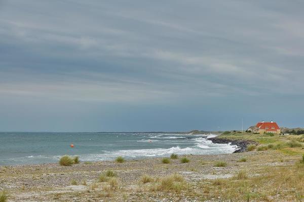 Skagen Skagen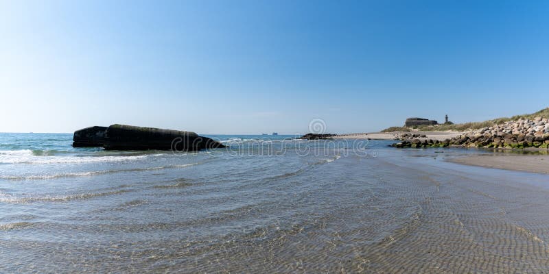 Old Bunkers at the beaches of Skagen Old Bunkers at the beaches of Skagen
|
|